Advanced search

google maps

About 241 results · showing 221–240 · page 12 of 13
S2 briefing · 2021-12-08

How to Make Maps

…and there we have it there's our map obviously practice makes perfect so the more that you practice with these kinds of systems the better your maps will be you'll be able to learn…
Intelligence Analysis
Military manual · ATP 2-33.4

ATP 2-33.4, page 141

Intelligence Analysis

Army Techniques Publication: Intelligence Analysis
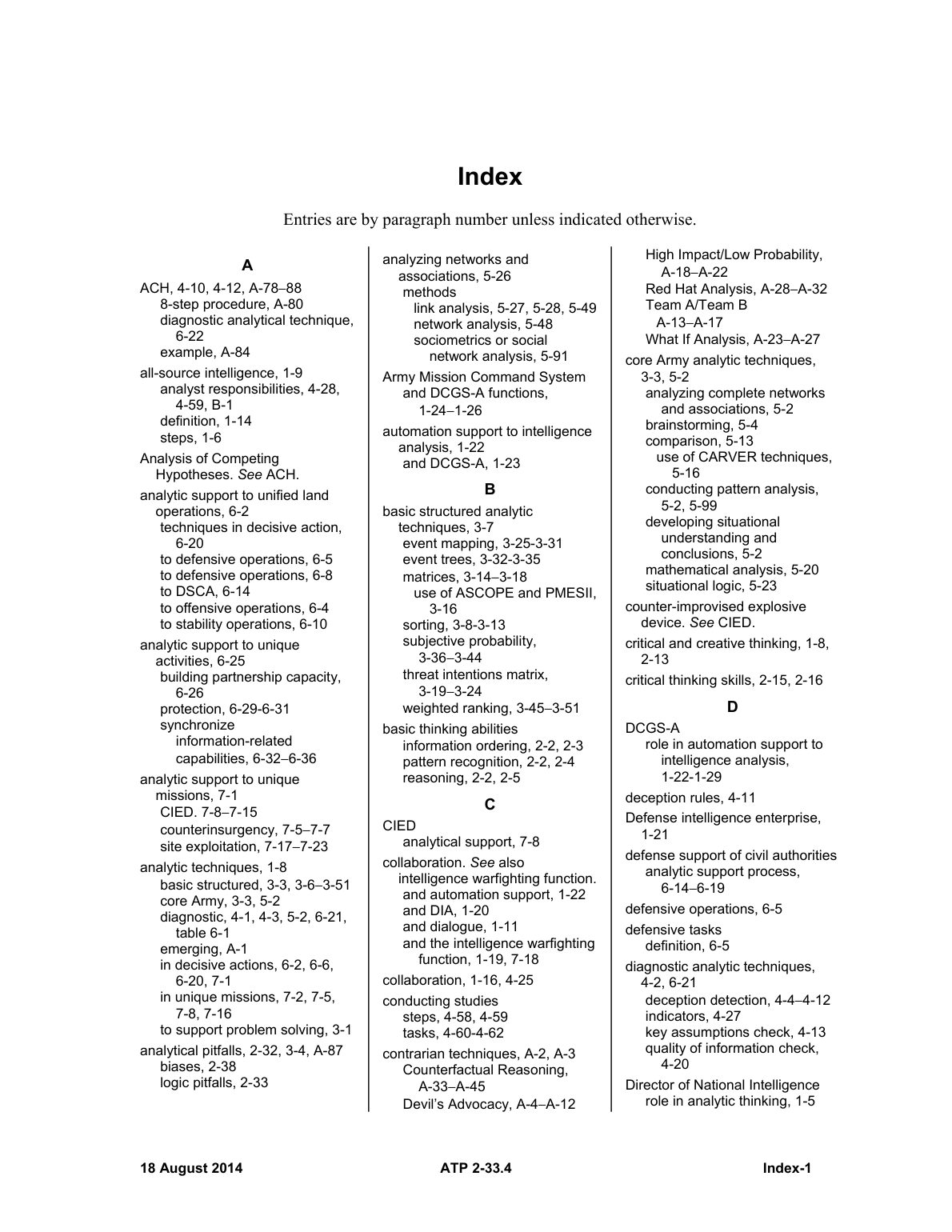
…intelligence analysis, 1-22 and DCGS-A, 1-23 B basic structured analytic techniques, 3-7 event mapping, 3-25-3-31 event trees, 3-32-3-35 matrices, 3-14−3-18 use of ASCOPE…
Joint Operations
Military manual · JP 3-0

JP 3-0, page 147

Joint Operations

Joint Publication: Joint Operations
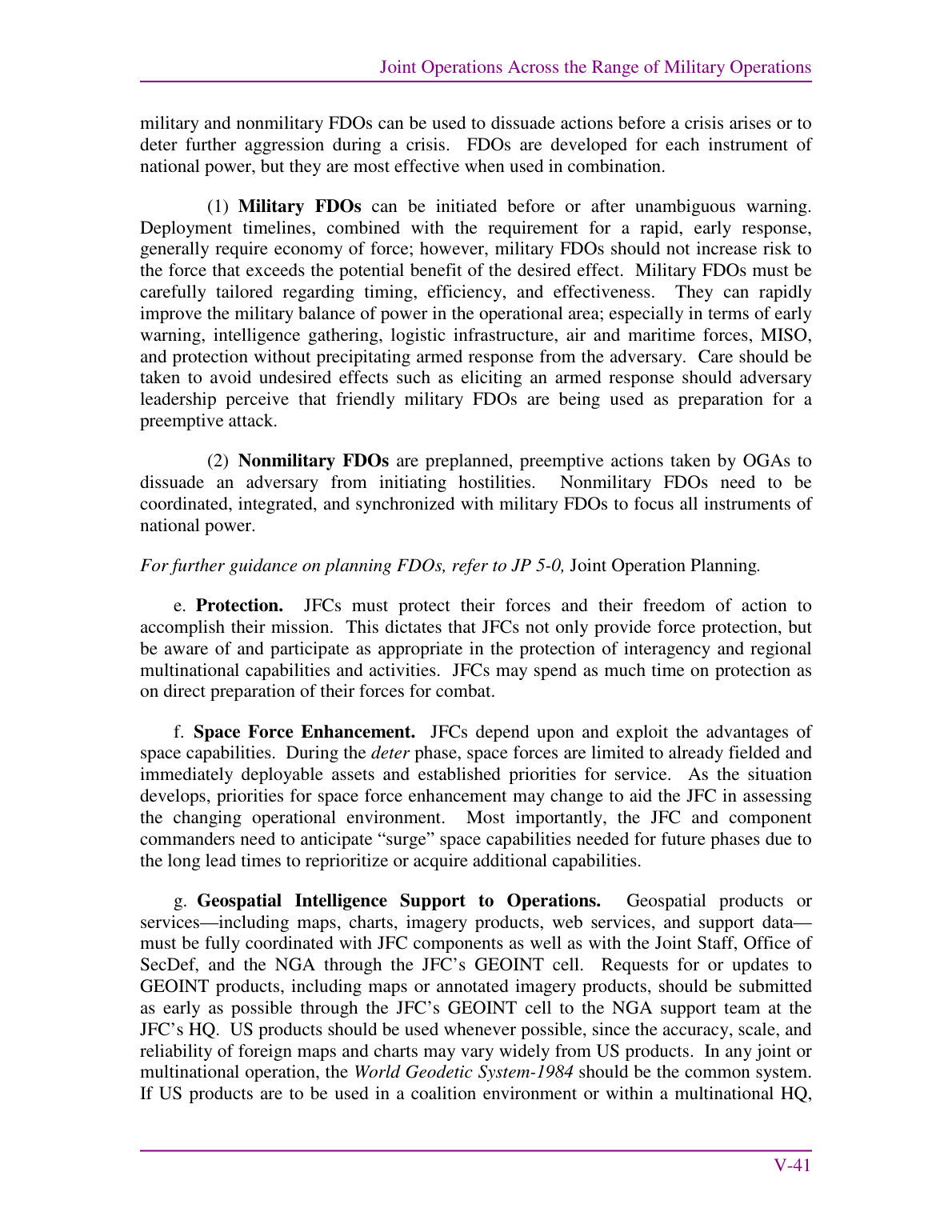
…Geospatial products or services—including maps, charts, imagery products, web services, and support data— must be fully coordinated with JFC components as well as with the Joint Staff, Office of SecDef, and the NGA through the…
Intelligence Analysis
Military manual · ATP 2-33.4

ATP 2-33.4, page 37

Intelligence Analysis

Army Techniques Publication: Intelligence Analysis

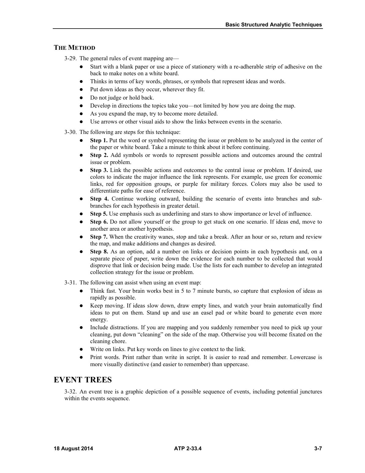
…e@ Develop in directions the topics take you—not limited by how you are doing the map. e As you expand the map, try to become more detailed. @ Use arrows or other visual aids to show…
Intelligence Analysis
Military manual · ATP 2-33.4

ATP 2-33.4, page 5

Intelligence Analysis

Army Techniques Publication: Intelligence Analysis

…Example of event mapping ............2.0...:c:ccceceseseseeceeeeseseereeseeeeeseeeeseeseseeneeeees OO Figuré:3=4.. Event tee OxaMple .i..:c.ccccccccsseices ces cictenaterscisanveteinerasiinaaanaraceciennesennececed OM Figure 3-5. Subjective probability example .................. cc cscsees este eeeeeeeeeeceeeteteeeeeeeteteeeeeeeeeeee OOD Figure 3-6. Weighted…
Offense and Defense
Military manual · ADP 3-90

ADP 3-90, page 49

Offense and Defense

Army Doctrine Publication: Offense and Defense
…A unit may—  Use printed maps and overlays to maintain a common operational picture within a command post.  Use combat network radios to transmit orders and reports.  Increase the use of liaison officers…
GhostNet Guide
S2 guide · GhostNet 1.5

GhostNet 1.5, page 26

GhostNet Guide

S2 Underground field guide: GhostNet Guide

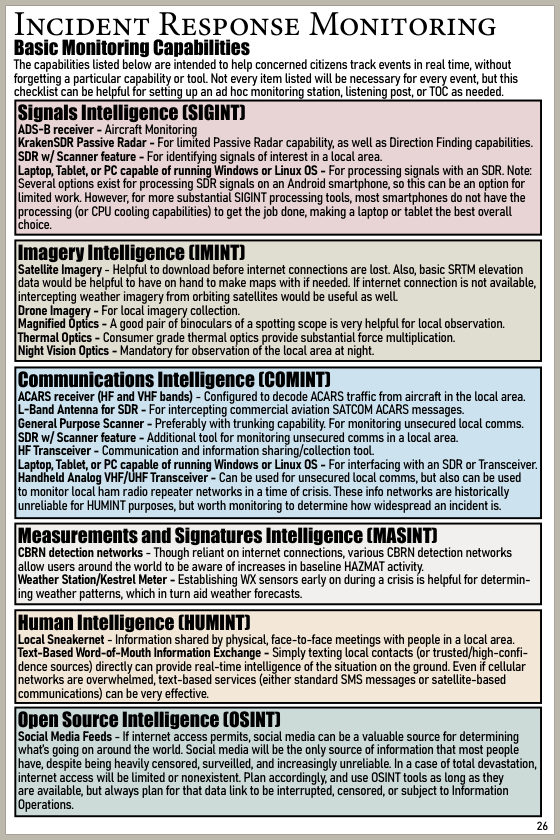
…Also, basic SRTM elevation data would be helpful to have on hand to make maps with if needed. If internet connection is not available, intercepting weather imagery from orbiting satellites would be useful as well. Drone…
Military Operations on Urbanized Terrain (MOUT)
Military manual · MCRP 12-10B.1

MCRP 12-10B.1, page 298

Military Operations on Urbanized Terrain (MOUT)

Marine Corps Reference Publication: Military Operations on Urbanized Terrain (MOUT)
…The squad leader should carry a map, compass, street plan, and notebook in which he/she has detailed the information that he/she must gather. One Marine is assigned to carry the tools needed to open…
Military Operations on Urbanized Terrain (MOUT)
Military manual · MCRP 12-10B.1

MCRP 12-10B.1, page 39

Military Operations on Urbanized Terrain (MOUT)

Marine Corps Reference Publication: Military Operations on Urbanized Terrain (MOUT)
…Composition and structure of buildings and roadbeds, cover and concealment opportunities, and other information not apparent in a map study may have a significant impact on the plan. (b) Phase II: Isolate the Objective. The objective…
Military Operations on Urbanized Terrain (MOUT)
Military manual · MCRP 12-10B.1

MCRP 12-10B.1, page 118

Military Operations on Urbanized Terrain (MOUT)

Marine Corps Reference Publication: Military Operations on Urbanized Terrain (MOUT)

…For example, small units conducting independent operations must have the communications capabilities and maps to allow them to call for fire. 4103. Mortars a. Employment of Mortars. Mortars are often the primary indirect-fire weapon for…
Military Operations on Urbanized Terrain (MOUT)
Military manual · MCRP 12-10B.1

MCRP 12-10B.1, page 8

Military Operations on Urbanized Terrain (MOUT)

Marine Corps Reference Publication: Military Operations on Urbanized Terrain (MOUT)

…Military Maps A - 67 35. Aerial Photographs A - 68 Section IX. Camouflage 36. Application A - 69 37. Use of Shadows A - 69 38. Color and Texture A - 69 Appendix B. Employment and Effects of Weapons 1…
Military Operations on Urbanized Terrain (MOUT)
Military manual · MCRP 12-10B.1

MCRP 12-10B.1, page 149

Military Operations on Urbanized Terrain (MOUT)

Marine Corps Reference Publication: Military Operations on Urbanized Terrain (MOUT)
…are essential to communications and intelligence gathering. (3) Topographic detachment is useful to provide necessary sketches and maps. (4) UAVs can be used for security, reconnaissance, and surveillance. (5) Whenever entering an AO, isolate the area…
Defense Support of Civil Authorities
Military manual · JP 3-28

JP 3-28, page 131

Defense Support of Civil Authorities

Joint Publication: Defense Support of Civil Authorities
…References: (List any maps, charts, and other relevant documents deemed essential to comprehension of the plan.) 1. Situation a. General. Describe the situation that requires DSCA. Identify the support category or categories of effort: domestic emergencies…
Military Operations on Urbanized Terrain (MOUT)
Military manual · MCRP 12-10B.1

MCRP 12-10B.1, page 36

Military Operations on Urbanized Terrain (MOUT)

Marine Corps Reference Publication: Military Operations on Urbanized Terrain (MOUT)

…Generally, military maps do not provide enough detail for urbanized terrain analysis. They usually do not show the underground sewer system, subways, underground water system, mass transit routes, and power plants. Local maps of intracity road…
Military Operations on Urbanized Terrain (MOUT)
Military manual · MCRP 12-10B.1

MCRP 12-10B.1, page 309

Military Operations on Urbanized Terrain (MOUT)

Marine Corps Reference Publication: Military Operations on Urbanized Terrain (MOUT)

…See FM 20-32.) The sketch should include the number of the building (taken from a city map, if available) and all floor plans. It should also include the type of mine and firing device. When…
Defense Support of Civil Authorities
Military manual · JP 3-28

JP 3-28, page 9

Defense Support of Civil Authorities

Joint Publication: Defense Support of Civil Authorities
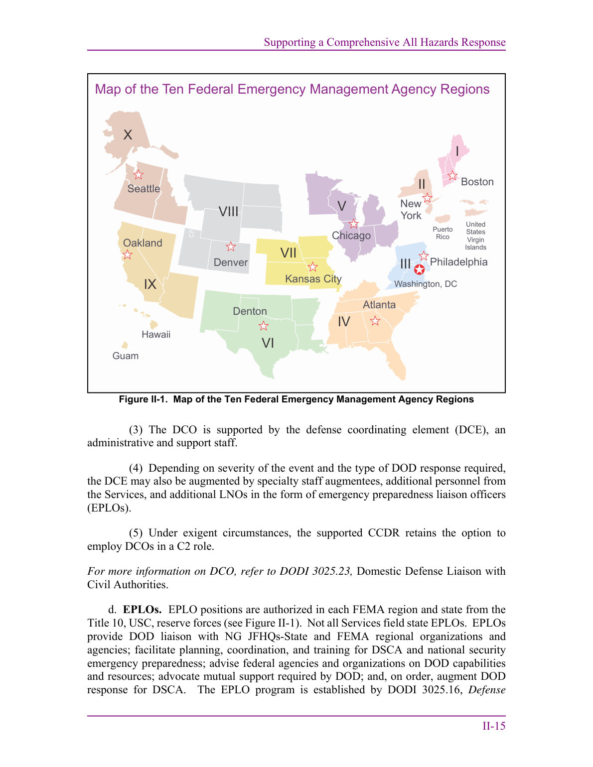
…I-7  II-1 Map of the Ten Federal Emergency Management Agency Regions .....................................................................................................II-15 II-2 Example Defense Support of Civil Authorities Objective to Standard Assignment (Combatant Command) .........................................II-20 II-3 Example Defense Support…
Military Operations on Urbanized Terrain (MOUT)
Military manual · MCRP 12-10B.1

MCRP 12-10B.1, page 332

Military Operations on Urbanized Terrain (MOUT)

Marine Corps Reference Publication: Military Operations on Urbanized Terrain (MOUT)
Following a clearly marked route to avoid obstacles and prevent the resupply vehicle(s) from becoming disoriented Providing radios to resupply vehicles Issuing each vehicle a map of the AO (preferably a city map with the…
Defense Support of Civil Authorities
Military manual · JP 3-28

JP 3-28, page 49

Defense Support of Civil Authorities

Joint Publication: Defense Support of Civil Authorities
…Map of the Ten Federal Emergency Management Agency Regions V III I II X VIII IV VII VI IX Atlanta Denton Map of the Ten Federal Emergency Management Agency Regions Denver Kansas City Philadelphia New York…
Military Operations on Urbanized Terrain (MOUT)
Military manual · MCRP 12-10B.1

MCRP 12-10B.1, page 47

Military Operations on Urbanized Terrain (MOUT)

Marine Corps Reference Publication: Military Operations on Urbanized Terrain (MOUT)
…Reconnaissance assets should not be risked indiscriminately if the information can be collected by other means. (3) Maps. Tactical maps should be supplemented by city street maps that contain street names and information on the location…
Military Operations on Urbanized Terrain (MOUT)
Military manual · MCRP 12-10B.1

MCRP 12-10B.1, page 229

Military Operations on Urbanized Terrain (MOUT)

Marine Corps Reference Publication: Military Operations on Urbanized Terrain (MOUT)

…Current aerial photographs are also excellent supplements to military city maps and can be substituted for a map. A topographical map or military city map could be obsolete if compiled many years ago. A recent aerial…